Extracts from a site survey
EXTRACTS from a Lincolnshire Gardens Trust site survey
Courtesy researcher/recorder Sue Barlow.
Location:
Aswarby Park, Aswarby, Lincolnshire, NG34 8SD
OS grid reference, TF 064 399
Parish, Historic County and District:
The Parish of Aswarby in North Kesteven, Lincolnshire.
Ownership:
Privately owned.
Access:
Occasionally open to the public. A public footpath borders north and east park boundaries.
Size:
160 acres – 1856 estate map drawn by the agent G.W. Mutter
Introduction:
Aswarby Park was established in the C18 or earlier, by the Whichcote family, and further developed throughout the C19. A boar’s head adorns the Whichote family crest.
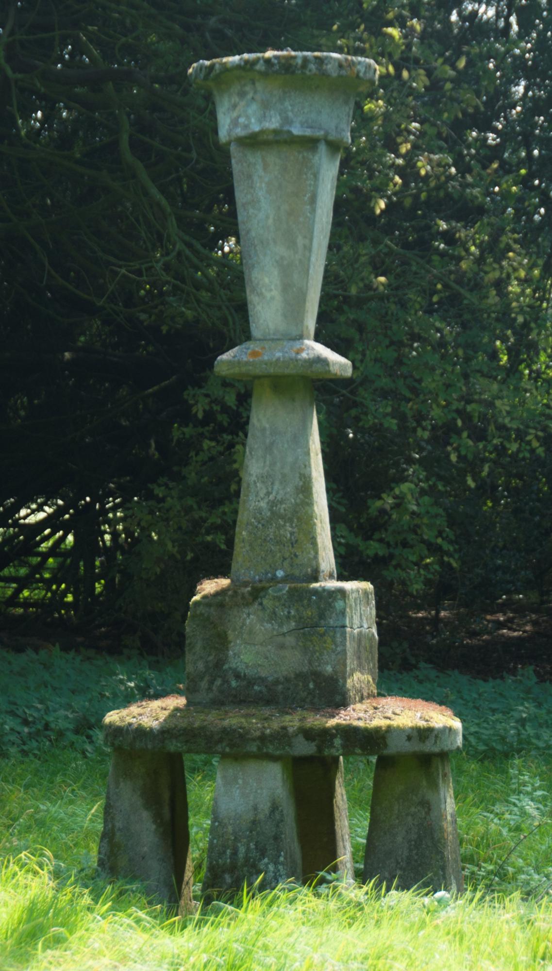
Two 18C ashlar masonry pillars, (Grade II) each with a boar’s head, likely mark the original approach to the hall.
Why have these survived isolated in the middle of the park?
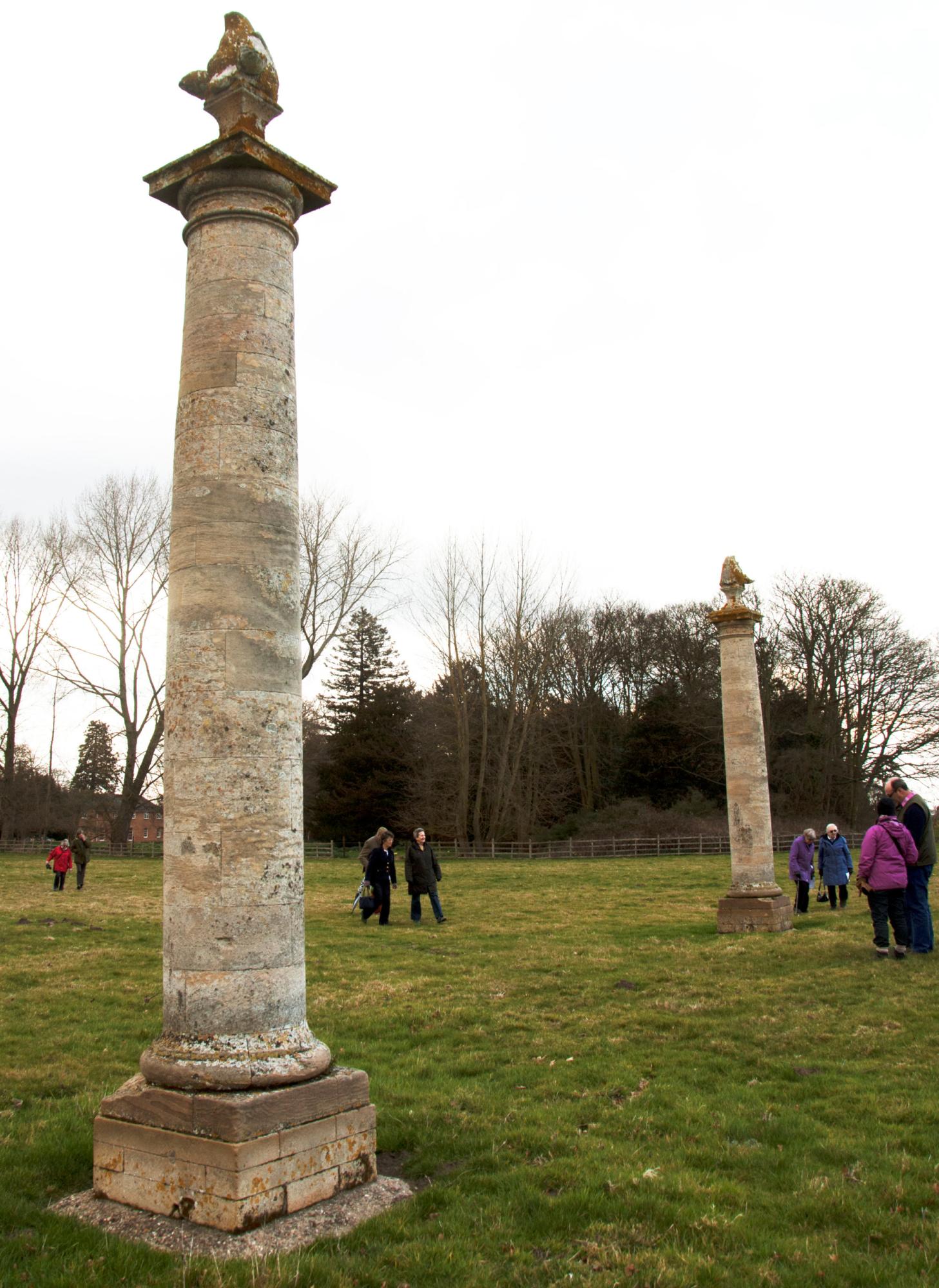
Surviving pillars at Aswarby park (image by Steffie Shields).
Study the enlarged 1906 OS
Find the old house (occupied by the military in WWII; demolished 1951) to the left and the stable courtyard in the middle.
19C century kennels for hunting dogs, today painted green and white with a stone lintel, are north of the stables.
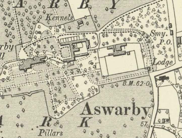
Detail of 1906 Ordnance Survey map, available on line at the Nation Library of Scotland site (maps.nls.uk)
The Arts & Crafts (Edwardian Period) park gate (below) with decorative pillars is situated north west of the house, with the garden and walks enclosed by a shallow ha-ha and rail fence. Little remains of a former lily pond between the house and the pillars.

Arts & Crafts park gate at Aswarby Park (image by Steffie Shields).
Note the main axis of the house linking the view south to the pillars (the original gate and direct formal approach). On the stable block, now the estate office and residence, a cartouche is seen (originally over the front door of the old house) and a clock, brought from Harpswell (the previous Whichcote family home) dated 1746 to mark the Battle of Culloden.
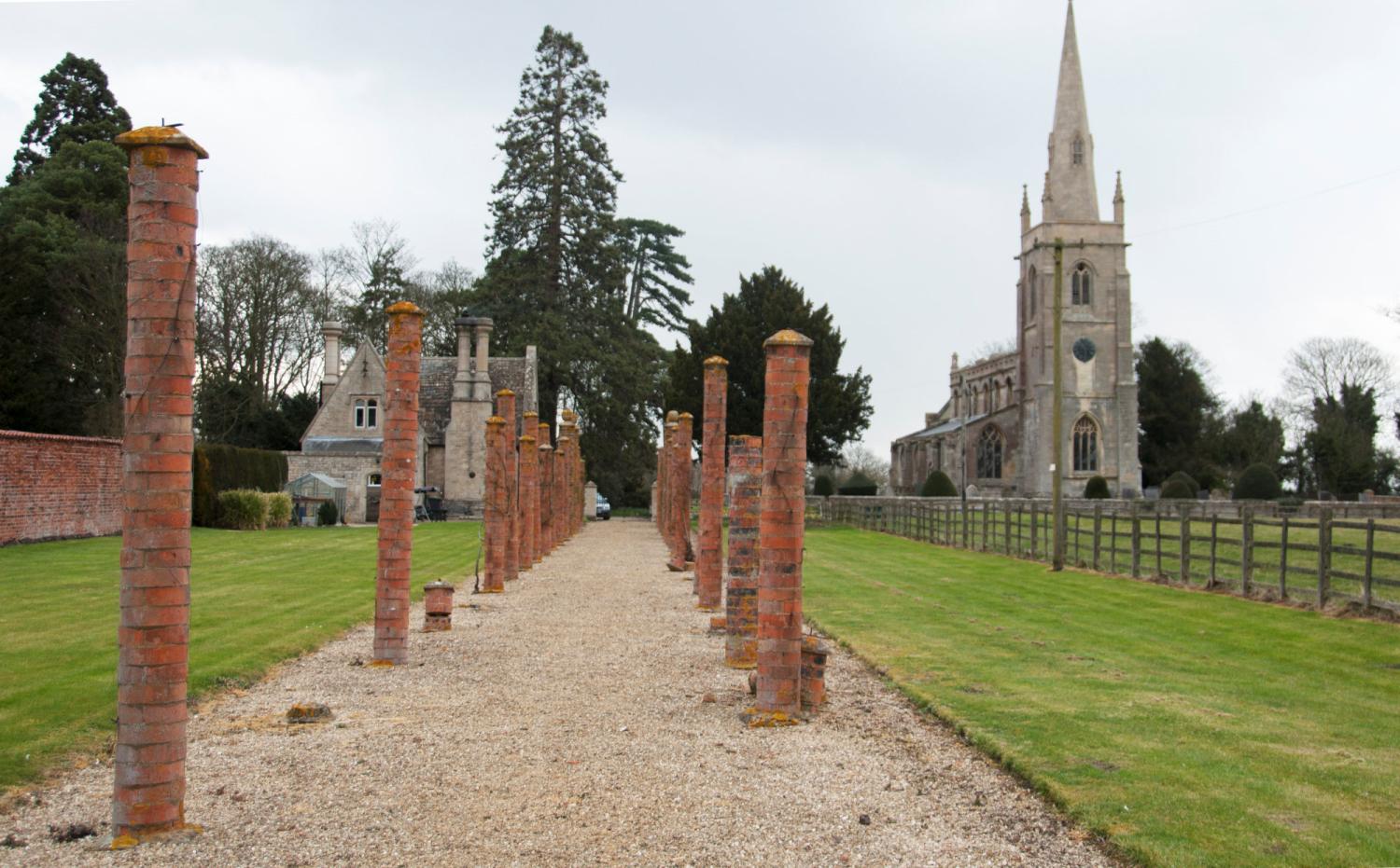
View along the Rose Walk at Aswarby Park (image by Steffie Shields).
The mid-19C Victorian walled garden, South Lodge, Rose Walk, and St Denys Church (right, HE Grade I, with parts dating back to 12C) all survive. 19C kennels for hunting dogs, painted green and white with a stone lintel, are north of the stables. Further to the west iron railings and gate with decorative posts open into the park. The cricket pitch can still be seen in the park.
South of the old house is a trellised summer house, overlooking the park, with a view to the church, and rock garden remains, made from small irregular stones, approximately all the same size, possibly a grotto and fernery. Two bridges cross a stream or culvert (mostly dry now). Nearby is a wooden octagonal summerhouse. The stream turns north and runs through the garden by the stable block eventually reaching the ice-house , (now filled in).
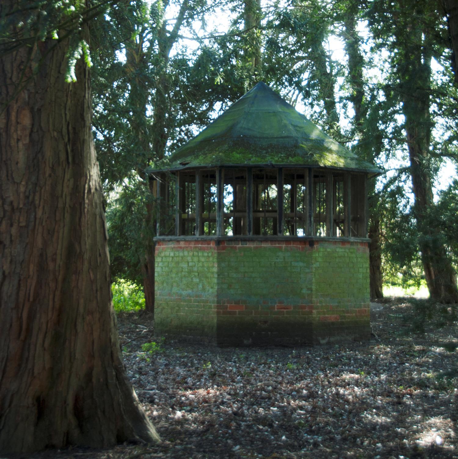
Octagonal summerhouse at Aswarby Park (image by Steffie Shields).

View of the walled garden at Aswarby Park, from the glasshouse (image by Steffie Shields).
The mid-19C Victorian one-acre walled garden (above) has an attached gardener’s bothy (accommodation for gardeners), and now modern glasshouse, with vine over 100 years old.
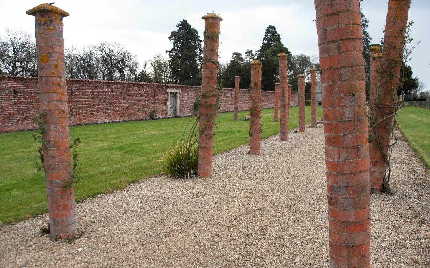
Adjacent to the walled garden on the south side, running parallel is a long mid-19C rose pergola, made up of 50 red brick pillars of various heights, topped with limestone caps, (some still planted with climbing roses today) This Rose Walk incorporates a short access path leading into the walled garden mid-way along its south wall. The pergola the frames views to the medieval village church with its picturesque tower and spire.
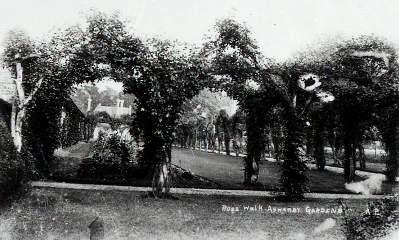
Postcard of Aswarby Rose Walk in the 1910s (image held in Lincolnshire Archives)
Notice the tall Wellingtonia trees that line the approach drive to the house from the South Lodge, in the Victorian era when there was interest in planting a Pinetum of imported conifers.
Timeline:
Old Danish name Aswarth, ecclesiastical parish within ancient Aswardun wapentake of the Danelaw. Noted as Aswardebi in the Domesday Book. Land owned by Gilbert de Gant and Guy de Craon. Later owned by de Kymes, Umfraville and Tailboys families.
16C Lady Ambrose Dudley, last of the Tailboys sold Aswarby estate to Robert Carre (d 1590) (uncle by marriage). Edward his youngest son eventually inherited the estate.
1618 to Edward’s second son Rochester Carre.
1637 Rochester was declared insane. Two factions of the family were in contention for his guardianship. The son of Lady Mary Carre forcibly seized the estate and held it for over a year although there were various trustees of Rochester Carre. He was finally ousted by the Sheriff of the County. Sir Adrian Scrope had married Lady Mary Carre and their son Carre Scrope was born at Aswarby in 1649. John 1st Earl of Bristol, married Isabella Carre, daughter of Robert Carre who died at Aswarby in 1682 and sister of Sir Edward Carre the last baronet who died in 1683 at the age of eighteen. 1723 Her son Carre, Lord Hervey died. Sir Francis Whichcote bought Aswarby. Descended from a Shropshire family, his first wife was daughter of Joseph Banks I of Revesby Abbey, and his second wife the widow of Sir Neville Hickman of Gainsborough. Sir Christopher Whichcote (1730-1812) married Jane, heiress of the Harpswell Whichcots [sic]. (In the 15th century the Whichcots had married into the Tyrwhitt family and the Aswarby Whichcotes were a branch of the same family).
1812 The estate was inherited by their son, Thomas Whichcote (1763-1828), and in turn his son another Thomas (1787-1829) and his son Thomas (1813-1892). His only daughter Isabella married the Marquis of Exeter and died in1917.
1892 The estate and baronetcy were inherited by Sir George Whichcote (1817-1893) the brother of the last Sir Thomas.
1893 The ninth baronet, Sir George Whichcote (1870-1949) succeeded his father and being unmarried the title then went to his brother Sir Hugh Whichcote (born 1874), who had three daughters.
1949 Sir George Whichcote left his estate to Mr Nicholas George Whichcote Playne, his great nephew and grandson of Sir Hugh Whichcote.
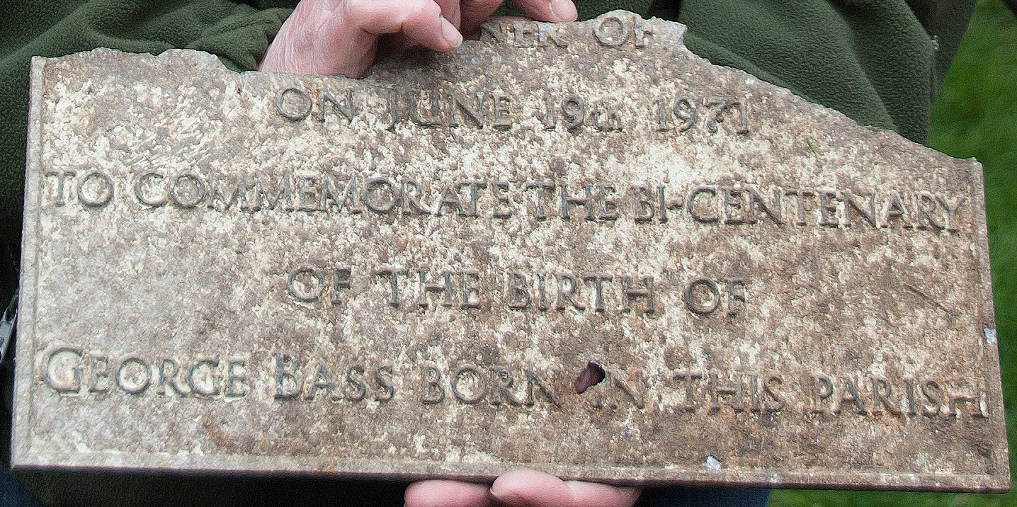
1971 An Australian conifer was planted by the Australian High Commissioner, visiting in connection with George Bass (1771 –1803), the explorer who was born in Aswarby village (plaque below. e in 2015).
History of Site:
The first recorded house on the site probably dated from 16C when the Carre family bought the estate and deer park. There is little detailed information on the park before the mid-19C. However, an inventory (1696) mentions melon glasses, gardening tools and a roller in the kitchen garden, suggesting that it provided the needs of the household. A bowling green is also mentioned [formal garden?]. Some evidence also indicates there were formal gardens in the time of Sir Francis Whichcote. In the 1730s a medicinal spring in the park drew ‘vast crowds’. A drawing of Aswarby Park by William Stukeley, 16 July 1730, shows a four-arch pavilion or arcade apparently at the end of a canal, with two church spires behind, all framed by plantations and may have been a bath-house serving the afore-mentioned medicinal spring. In 1755 Byng, an 18C travelling commentator and diarist described the park as ‘a Moorish flat’.
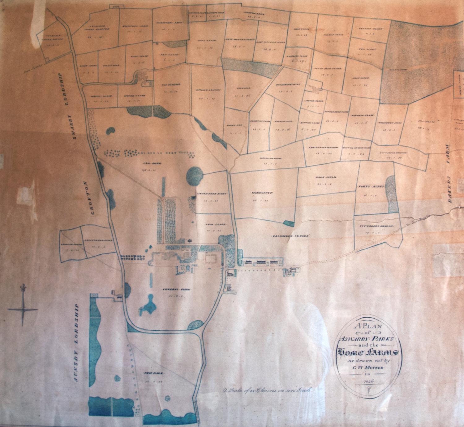
Detail from 19th century estate map of Aswarby Parks (original held by Aswarby Park).
In the 18C century, the house was partly demolished and rebuilt in Georgian style, retaining some of the old house as the east wing. 18C stone gate piers, each with a boar’s head, still standing in the park south, indicate where the original road from Folkingham to Sleaford road passed nearer to the house. Arial photography also shows a boundary bank, ha-ha and formal gardens. in 1836-8 H.E Kendall (1776 – 1875) made further modifications, including the addition of the large bay on the south front. The Whichcotes went on to develop and expand the estate by moving the village and adding stable block, also designed by Kendall, walled garden and gardener’s bothy, kennels, rose pergola, north and south lodges on new approach drives smithy and brickyard, all recorded on Estate map drawn by the agent, GW Mutter (1836) also showing a pond in the park to the south, and a second small canal (possibly a decoy) on Mutter’s plan. A mound in the park may be a bronze age round barrow, but there is a local story that it is the burial ground of an elephant, belonging to an early 20C circus travelling from Bourne to Sleaford. A new enclosure, New Park, was created south of main road (refer to large 1905 OS map above) with horizon plantations still extant on the hill today. A drive running directly north from the house and flanked by trees, turns west to leave the estate by the North Lodge, on the main road to Lincoln.
Equestrian artist, John Fernely (1782 -1860), the stayed at The Tally Ho Inn. originally the farm manager’s house, while painting the Whichcote horses and hunting scenes. An avenue of trees (re-planted late 2OC) runs west from the house. An 1856 map also shows a path running south from the two-storey, semi-circular bay on the south front of the house to a central bastion in the terrace bounding the garden to the south. The 1886-1897 OS map shows a round pond or flower bed on this axis. The late 19C century gardens followed the current fashion for colourful bedding in different designs, and expanses of smooth lawns to the south, south-east and south-west of the house with enclosing shrubbery walks to the north with an iron- gate and north west approach. Lady Whichcote opened the gardens in the summer of 1880 to hundreds of visitors when ‘Mr Nisbett, the originator in this district of carpet bedding, […] exceeded anything before attempted’. Photographs from the 1910s shows that the rose pergola was more extensive than it is today and was fully clothed with plants, where a flower border includes delphiniums and foxgloves, between the pergola and the south wall of the walled garden. The greenhouse, equipped with a stove, provided bedding plants, orchids, ferns, palms, lilies, cape pelargoniums, geraniums and calceolarias. The main house was occupied by the military during the Second World War and demolished in 1951. The stable block was converted into a house and estate office.
Official and Other Designations:
In 2017 Aswarby Park was registered Grade II on the Historic England Parks and Gardens Register. The principal reasons for listing the park as follows:
- Listed Buildings (Historic England)
- Aswarby Park: Walled Garden and Gardener’s Bothy. Grade II
- Aswarby Park: The Kennels. Grade II
- Aswarby Park: Rose Pergola. Grade II
- Aswarby Park: Pair of Pillars. Grade II
- Aswarby Park: Estate Office with attached walls and buildings. Grade II
- Aswarby Park, London Road, (east side): North Lodge. Grade II
- Aswarby Park, Main Street (north side): South Lodge with attached wall and gateway. Grade II
- Aswarby Park, Wood Lane (west side): The Old Smithy. Grade II
Ecology:
Shallow permeable calcareous fine loamy soils over limestone. A stream, North Beck, runs from west to east across the northern part of the park.
Recorder:
Sue Barlow Lincolnshire Gardens Trust
Date visited:
18th September 2014
References:
Maps:
OS Sheet CXV.6 25″1905; OS Map 115/NW 1886-1897; OS Landranger map Sheet 130.,
Archives:
Lincolnshire Archives: MCD 397. Deed, 4th July 1696, Schedule of Household goods at Aswarby House.
www.lincstothepast.com MLI 90332. Settlement of Aswarby Photograph from 1910s. ML230b
William Stukeley Drawing (Bodleian Library)
Other References:
www.historicengland.org.uk/listing/the-list Listed Buildings
Pevsner, N. and J. Harris, 2nd ed., revised by N. Antram The Buildings of England – Lincolnshire, 1989. p.108-9
Henry Thorold, Lincolnshire Houses, 1999
Robert Pacey, Lost Lincolnshire Houses, Volume 6, (2010)
Terence Leach, Lincolnshire Country Houses and Their Families. Part One, (2009).
Pastscape (Historic England) website
Wikipedia (from Vision of Britain – Aswardun).
Photograph c.1900 from REVIVALHERITAGE website
Conclusion:
The HISTORIC SIGNIFICANCE of Aswarby Park (REF: Historic England 2017 report)
- Historic interest:
as an evolved, country-house landscape dating from at least the early C18, which retains visible evidence of its evolution and phases of development in the form of buildings and planned landscape features; - Architectural interest:
as displayed by the estate buildings and structures which survive within the park landscape, including lodges, kennels, a walled garden and gardeners’ bothy, almost all of which are listed buildings; - Archaeological interest:
the extensive survival of ridge and furrow as evidence of medieval plough land, and the earthwork remains of Aswarby village, demolished to make way for C19 improvements to the park, add significantly to the special interest of the park landscape; - Group value:
Aswarby Park has strong geographic group value with the Medieval Parish Church of St Denys, listed at Grade I, and the Tally Ho public house, Glebe Cottage, 1 and 2, 3 and 5, and 6 and 7 Main Street, 1 and 2 Wood Lane, the Old Smithy, and the Estate Office, all located near the park boundary and all listed at Grade II.